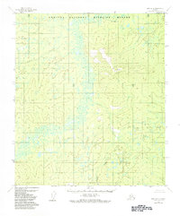
1952 Map of Ruby B-4
USGS Topo · Published 1984About this map
Nowitna National Wildlife Refuge encompasses the majority of this interior Alaskan landscape, characterized by the winding course of the Sulatna River. The terrain is dominated by the Monzonite Hills in the northeast, rising above the surrounding lowlands. A prominent Trail cuts across the western section near Flint Creek, indicating early overland travel routes through this remote territory. The drainage system is extensive, including Bonanza Creek, Little Bonanza Creek, and the Bonanza Valley. Surveyed by the U.S. Geological Survey using aerial photographs from 1952, this map provides a detailed view of the unsurveyed and unmarked land lines as they existed in the mid-20th century. High points like VABM Flint and the tributaries of Monzonite Creek and Cottonwood Creek reflect the complex hydrology of the Yukon-Koyukuk region before later modern developments.
Find a feature on this map
11 named features on this map. Tap any name to fly to it.
Don’t see what you’re looking for? This feature index may not catch every label — zoom into the map to look around manually.
Map Details
Editions of this 1952 Ruby B-4 Map
3 editions found
Other maps of this area

1951 · Ruby
USGS Topo · 1:250,000

1952 · Ruby A-3
USGS Topo · 1:63,360

1952 · Ruby A-4
USGS Topo · 1:63,360

1952 · Ruby C-3
USGS Topo · 1:63,360

1952 · Ruby B-4
USGS Topo · 1:63,360

1952 · Ruby C-5
USGS Topo · 1:63,360

1952 · Ruby B-3
USGS Topo · 1:63,360

1952 · Ruby B-5
USGS Topo · 1:63,360

1952 · Ruby A-5
USGS Topo · 1:63,360

1952 · Ruby C-4
USGS Topo · 1:63,360