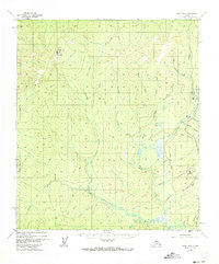
1952 Map of Ruby B-6
USGS Topo · Published 1973About this map
Yuki Mountain stands as a prominent landmark in this interior Alaskan wilderness, overlooking a drainage system defined by the Sulatna River and its numerous tributaries. The landscape is marked by the presence of industrial activity from the mid-20th century, particularly visible through the Strip Mine and a Placer Mine located in the eastern portion of the survey. Transportation in this remote environment relied heavily on aviation, evidenced by the primary Landing Strip and the specialized Greenstone Landing Strip near the confluence of Creek 2 and Greenstone Creek. These small outposts and scattered Cabins suggest a seasonal or industrial settlement pattern typical of the era's mining frontier. Waterways like Long Creek and Fifth of July Creek carve through the terrain, illustrating the complex hydrology of the region before significant modern development altered the land.
Find a feature on this map
25 named features on this map. Tap any name to fly to it.
Don’t see what you’re looking for? This feature index may not catch every label — zoom into the map to look around manually.
Map Details
Editions of this 1952 Ruby B-6 Map
3 editions found
Other maps of this area

1945 · Nulato
USGS Topo · 1:250,000

1951 · Nulato
USGS Topo · 1:250,000

1951 · Ruby
USGS Topo · 1:250,000

1952 · Nulato C-1
USGS Topo · 1:63,360

1952 · Nulato B-1
USGS Topo · 1:63,360

1952 · Ruby B-6
USGS Topo · 1:63,360

1952 · Ruby C-5
USGS Topo · 1:63,360

1952 · Ruby B-5
USGS Topo · 1:63,360

1952 · Ruby A-5
USGS Topo · 1:63,360

1952 · Ruby A-6
USGS Topo · 1:63,360