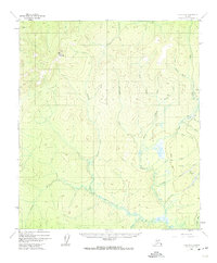
1952 Map of Ruby B-6
USGS Topo · Published 1974About this map
Yuki Mountain stands as a prominent landmark in this interior Alaskan wilderness, overlooking a landscape defined by gold-bearing drainages and early aviation access. Surveyed in the early 1950s, the terrain reveals a network of mining activity concentrated along the eastern creeks. The presence of a Placer Mine near Willow Creek and a Strip Mine further south suggests the ongoing extraction of mineral wealth during the mid-century period. Access to these remote operations relied on a Landing Strip and the established Winter Trail, reflecting the seasonal logistics required for northern industry.
Find a feature on this map
23 named features on this map. Tap any name to fly to it.
Don’t see what you’re looking for? This feature index may not catch every label — zoom into the map to look around manually.
Map Details
Editions of this 1952 Ruby B-6 Map
3 editions found
Other maps of this area

1945 · Nulato
USGS Topo · 1:250,000

1951 · Nulato
USGS Topo · 1:250,000

1951 · Ruby
USGS Topo · 1:250,000

1952 · Nulato C-1
USGS Topo · 1:63,360

1952 · Nulato B-1
USGS Topo · 1:63,360

1952 · Ruby B-6
USGS Topo · 1:63,360

1952 · Ruby C-5
USGS Topo · 1:63,360

1952 · Ruby B-5
USGS Topo · 1:63,360

1952 · Ruby A-5
USGS Topo · 1:63,360

1952 · Ruby A-6
USGS Topo · 1:63,360