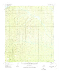
1952 Map of Ruby C-5
USGS Topo · Published 1975About this map
Ruby sits along the southern bank of the Yukon River at the northwestern corner of this interior Alaskan landscape, serving as a vital transportation and communication hub. The infrastructure of the mid-twentieth century is evident through the presence of a Landing Strip, a Gaging Sta, and Radio Towers positioned near the settlement. The surrounding terrain is defined by high points such as Cecil Dome and Boston Dome, while numerous waterways including Big Glacier Creek and Thirteenmile Creek carve through the wilderness. These interior drainage patterns are punctuated by scattered Cabins, indicating seasonal use or remote dwellings connected to the river and trail systems. To the south, prominent landmarks like Devils Thumb and Scow Mountain provide navigational reference points across the expansive network of creeks and gulches, including Fox Gulch and Dominion Creek.
Find a feature on this map
27 named features on this map. Tap any name to fly to it.
Don’t see what you’re looking for? This feature index may not catch every label — zoom into the map to look around manually.
Map Details
Editions of this 1952 Ruby C-5 Map
4 editions found
Other maps of this area

1951 · Ruby
USGS Topo · 1:250,000

1952 · Ruby D-6
USGS Topo · 1:63,360

1952 · Ruby D-4
USGS Topo · 1:63,360

1952 · Ruby D-5
USGS Topo · 1:63,360

1952 · Ruby B-6
USGS Topo · 1:63,360

1952 · Ruby B-4
USGS Topo · 1:63,360

1952 · Ruby C-5
USGS Topo · 1:63,360

1952 · Ruby B-5
USGS Topo · 1:63,360

1952 · Ruby C-4
USGS Topo · 1:63,360

1952 · Ruby C-6
USGS Topo · 1:63,360