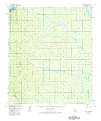
1952 Map of Ruby C-5
USGS Topo · Published 1984About this map
The Yukon River defines the northwestern edge of this 1952 topographic study, where the settlement of Ruby serves as a vital point of contact between the river and the interior. The presence of a Landing Strip, Radio Towers, and a Gaging Sta indicates the town's role as a regional communications and transportation hub during the early 1950s. Moving inland from the Corporate Boundary, the landscape is dominated by high points like Boston Dome and Cecil Dome, while a dense network of drainages including Big Creek and Beaver Creek suggests a terrain shaped by heavy seasonal runoff. This survey is particularly useful for identifying small, isolated Cabin sites and industrial markers like a Gravel Pit or VABM 931 Boston, which anchor the geography of the surrounding wilderness.
Find a feature on this map
33 named features on this map. Tap any name to fly to it.
Don’t see what you’re looking for? This feature index may not catch every label — zoom into the map to look around manually.
Map Details
Editions of this 1952 Ruby C-5 Map
4 editions found
Other maps of this area

1951 · Ruby
USGS Topo · 1:250,000

1952 · Ruby D-6
USGS Topo · 1:63,360

1952 · Ruby D-4
USGS Topo · 1:63,360

1952 · Ruby D-5
USGS Topo · 1:63,360

1952 · Ruby B-6
USGS Topo · 1:63,360

1952 · Ruby B-4
USGS Topo · 1:63,360

1952 · Ruby C-5
USGS Topo · 1:63,360

1952 · Ruby B-5
USGS Topo · 1:63,360

1952 · Ruby C-4
USGS Topo · 1:63,360

1952 · Ruby C-6
USGS Topo · 1:63,360