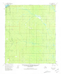
1952 Map of Ruby C-5
USGS Topo · Published 1981About this map
The settlement of Ruby sits on the southern bank of the Yukon River, serving as a gateway to the gold-bearing interior during this mid-century survey. The landscape is defined by the high prominence of Boston Dome and Cecil Dome, landmarks that guided prospectors moving south into the intricate drainage basins of Beaver Creek and Hunter Creek. The presence of a Gaging Sta and Radio Towers near the riverfront highlights the area's role as a vital communication and transportation hub in the Alaskan bush.
Find a feature on this map
28 named features on this map. Tap any name to fly to it.
Don’t see what you’re looking for? This feature index may not catch every label — zoom into the map to look around manually.
Map Details
Editions of this 1952 Ruby C-5 Map
4 editions found
Other maps of this area

1951 · Ruby
USGS Topo · 1:250,000

1952 · Ruby D-6
USGS Topo · 1:63,360

1952 · Ruby D-4
USGS Topo · 1:63,360

1952 · Ruby D-5
USGS Topo · 1:63,360

1952 · Ruby B-6
USGS Topo · 1:63,360

1952 · Ruby B-4
USGS Topo · 1:63,360

1952 · Ruby C-5
USGS Topo · 1:63,360

1952 · Ruby B-5
USGS Topo · 1:63,360

1952 · Ruby C-4
USGS Topo · 1:63,360

1952 · Ruby C-6
USGS Topo · 1:63,360