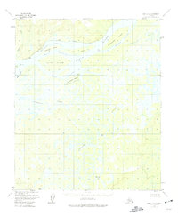
1952 Map of Ruby D-3
USGS Topo · Published 1975About this map
The Yukon River dominates this landscape, splitting into complex channels and sloughs around massive landforms like Kathaleen Island and Edith Island. This mid-century survey reveals a river-dependent environment where the settlement of Florence and several remote Cabins serve as the only human outposts amidst a labyrinth of waterways. The presence of an abandoned Telegraph Line following the Western Channel speaks to the early communication infrastructure that once connected these remote Alaskan interior reaches. Further south, the Nowitna River meanders through low-lying terrain, forming distinctive oxbows such as The Loop. The intricate network of Novakaket Slough and Junekaket Creek highlights the seasonally shifting nature of the floodplain, which dictated the placement of early dwellings and river navigation routes.
Find a feature on this map
26 named features on this map. Tap any name to fly to it.
Don’t see what you’re looking for? This feature index may not catch every label — zoom into the map to look around manually.
Map Details
Editions of this 1952 Ruby D-3 Map
2 editions found
Other maps of this area

1951 · Ruby
USGS Topo · 1:250,000

1951 · Melozitna
USGS Topo · 1:250,000

1952 · Ruby D-4
USGS Topo · 1:63,360

1952 · Ruby C-3
USGS Topo · 1:63,360

1952 · Melozitna A-2
USGS Topo · 1:63,360

1952 · Ruby C-2
USGS Topo · 1:63,360

1952 · Ruby D-3
USGS Topo · 1:63,360

1952 · Ruby D-2
USGS Topo · 1:63,360

1952 · Ruby C-4
USGS Topo · 1:63,360

1952 · Ruby
USGS Topo · 1:250,000