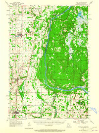
1955 Map of Rush City
USGS Topo · Published 1965About this map
The St Croix River serves as the primary boundary and geographical anchor for this mid-century survey, dividing Minnesota and Wisconsin across a landscape of agriculture and woodland. On the western bank in Chisago County, the Northern Pacific railroad corridor connects the primary settlements of Rush City and North Branch, showing the established transportation network before the interstate era. This region is characterized by small townships like Rushseba and Sunrise, where local life centered around rural landmarks such as East Rock Creek Ch and Pleasant Prairie Ch.
Find a feature on this map
40 named features on this map. Tap any name to fly to it.
Don’t see what you’re looking for? This feature index may not catch every label — zoom into the map to look around manually.
Map Details
Editions of this 1955 Rush City Map
5 editions found
Other maps of this area

1900 · St Croix Dalles
USGS Topo · 1:62,500

1901 · St Croix Dalles
USGS Topo · 1:62,500

1950 · Rush City
USGS Topo · 1:48,000

1950 · Grantsburg
USGS Topo · 1:48,000

1951 · Milltown
USGS Topo · 1:48,000

1953 · Stillwater
USGS Topo · 1:250,000

1955 · St. Croix Dalles
USGS Topo · 1:62,500

1955 · Rush City
USGS Topo · 1:62,500

1955 · Milltown
USGS Topo · 1:62,500

1955 · Forest Lake
USGS Topo · 1:62,500