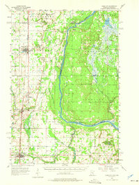
1955 Map of Rush City
USGS Topo · Published 1975About this map
The St Croix River forms a prominent natural boundary between Minnesota and Wisconsin, winding through a landscape shaped by glacial deposits and timber history. This mid-century survey reveals the established rail-and-river towns of Rush City and North Branch along the Northern Pacific railroad line, serving as local hubs for the surrounding farming townships. The eastern portion of the map showcases the river's complex hydrology, including the Lagoon and several creeks feeding into the main channel near Benson and Sunrise.
Find a feature on this map
44 named features on this map. Tap any name to fly to it.
Don’t see what you’re looking for? This feature index may not catch every label — zoom into the map to look around manually.
Map Details
Editions of this 1955 Rush City Map
5 editions found
Other maps of this area

1900 · St Croix Dalles
USGS Topo · 1:62,500

1901 · St Croix Dalles
USGS Topo · 1:62,500

1950 · Rush City
USGS Topo · 1:48,000

1950 · Grantsburg
USGS Topo · 1:48,000

1951 · Milltown
USGS Topo · 1:48,000

1953 · Stillwater
USGS Topo · 1:250,000

1955 · St. Croix Dalles
USGS Topo · 1:62,500

1955 · Rush City
USGS Topo · 1:62,500

1955 · Milltown
USGS Topo · 1:62,500

1955 · Forest Lake
USGS Topo · 1:62,500