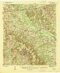
1945 Map of Rusk
USGS Topo · Published 1945About this map
Summerfield and Gallatin serve as northern anchors for this mid-century view of Cherokee County, where the iron-ore rich hills of East Texas meet the agricultural bottomlands of Mud Creek. The landscape is defined by the intersection of the Missouri Pacific and Southern Pacific railroads, which facilitated the movement of timber and produce from settlements like Dialville and Ponta. In the countryside, a dense network of community centers such as Sweet Union Ch, Afton Grove Sch, and Lyra Chapel reveals the social fabric of rural life during the 1940s. Genealogists will find particular value in the clearly marked family and community burial grounds, including McDonald Cem and the Myrtle Springs Cem. The topography is punctuated by prominent landmarks like Acker Mtn and the winding Caney Creek, illustrating the transition from wooded uplands to the valley of the Angelina River.
Find a feature on this map
59 named features on this map. Tap any name to fly to it.
Don’t see what you’re looking for? This feature index may not catch every label — zoom into the map to look around manually.
Map Details
Editions of this 1945 Rusk Map
2 editions found
Other maps of this area

1935 · Henderson
USGS Topo · 1:48,000

1937 · Troupe
USGS Topo · 1:48,000

1939 · Henderson
USGS Topo · 1:62,500

1943 · Troup
USGS Topo · 1:62,500

1943 · Cushing
USGS Topo · 1:62,500

1943 · Rusk
USGS Topo · 1:62,500

1945 · Cushing
USGS Topo · 1:62,500

1945 · Rusk
USGS Topo · 1:62,500

1946 · Alto
USGS Topo · 1:62,500

1946 · Bullard
USGS Topo · 1:62,500