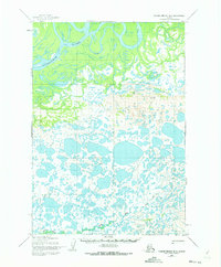
1954 Map of Russian Mission B-4
USGS Topo · Published 1973About this map
The Kuskokwim River dominates the northern reaches of this landscape, its wide channel and complex braids cutting through the wetland terrain of the Bethel region. This 1950s survey, updated with minor revisions in the early 1970s, captures a wilderness defined by water and seasonal transit. A significant Winter Trail provides the primary overland connection through the southern marshes, threading between a dense network of unnamed lakes and ponds toward the winding course of Bogus Creek. Geodetic markers such as Vabm Forks, Vabm Birch, and Vabm White serve as the only named landmarks in an area where surveying was primarily conducted through photogrammetric methods from 1952 aerial photography. The lack of permanent settlements emphasizes the region's reliance on riverine travel and seasonal routes during the mid-century era.
Find a feature on this map
7 named features on this map. Tap any name to fly to it.
Don’t see what you’re looking for? This feature index may not catch every label — zoom into the map to look around manually.
Map Details
Editions of this 1954 Russian Mission B-4 Map
3 editions found
Other maps of this area

1947 · Russian Mission
USGS Topo · 1:250,000

1950 · Russian Mission
USGS Topo · 1:250,000

1952 · Russian Mission C-3
USGS Topo · 1:63,360

1952 · Russian Mission C-5
USGS Topo · 1:63,360

1952 · Russian Mission B-3
USGS Topo · 1:63,360

1954 · Russian Mission A-4
USGS Topo · 1:63,360

1954 · Russian Mission B-5
USGS Topo · 1:63,360

1954 · Russian Mission A-5
USGS Topo · 1:63,360

1954 · Russian Mission C-4
USGS Topo · 1:63,360

1954 · Russian Mission B-4
USGS Topo · 1:63,360