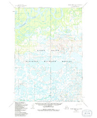
1954 Map of Russian Mission B-4
USGS Topo · Published 1991About this map
The Kuskokwim River meanders through the northern reaches of this landscape, its complex system of sloughs and oxbows defining the alluvial character of the region. Much of the area is contained within the Yukon Delta National Wildlife Refuge, a vast wetland environment characterized by a dense concentration of lakes and ponds. Topographical landmarks such as VABM Birch, VABM Forks, and VABM White provide essential vertical reference points in an otherwise low-lying delta.
Find a feature on this map
7 named features on this map. Tap any name to fly to it.
Don’t see what you’re looking for? This feature index may not catch every label — zoom into the map to look around manually.
Map Details
Editions of this 1954 Russian Mission B-4 Map
3 editions found
Other maps of this area

1947 · Russian Mission
USGS Topo · 1:250,000

1950 · Russian Mission
USGS Topo · 1:250,000

1952 · Russian Mission C-3
USGS Topo · 1:63,360

1952 · Russian Mission C-5
USGS Topo · 1:63,360

1952 · Russian Mission B-3
USGS Topo · 1:63,360

1954 · Russian Mission A-4
USGS Topo · 1:63,360

1954 · Russian Mission B-5
USGS Topo · 1:63,360

1954 · Russian Mission A-5
USGS Topo · 1:63,360

1954 · Russian Mission C-4
USGS Topo · 1:63,360

1954 · Russian Mission B-4
USGS Topo · 1:63,360