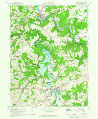
1964 Map of Saltsburg
USGS Topo · Published 1966About this map
The Kiskiminetas River and Conemaugh River converge at the historic borough of Saltsburg, a focal point of this mid-1960s topographic study. The landscape is defined by the massive footprint of the Loyalhanna Dam and its subsequent Loyalhanna Reservoir, which dramatically reshaped the drainage of Loyalhanna Creek. To the south, the village of New Alexandria serves as a secondary hub near the New Alexandria Airport and the waters of New Alexandria Reservoir.
Find a feature on this map
45 named features on this map. Tap any name to fly to it.
Don’t see what you’re looking for? This feature index may not catch every label — zoom into the map to look around manually.
Map Details
Editions of this 1964 Saltsburg Map
3 editions found
Other maps of this area

1900 · Latrobe
USGS Topo · 1:62,500

1902 · Latrobe
USGS Topo · 1:62,500

1902 · Elders Ridge
USGS Topo · 1:62,500

1903 · Latrobe
USGS Topo · 1:62,500

1904 · Elders Ridge
USGS Topo · 1:62,500

1904 · Greensburg
USGS Topo · 1:62,500

1906 · Greensburg
USGS Topo · 1:62,500

1907 · Freeport
USGS Topo · 1:62,500

1909 · Freeport
USGS Topo · 1:62,500

1953 · Pittsburgh
USGS Topo · 1:250,000
Featured Places
- White, Conemaugh Township
- Saltsburg, PA
- New Alexandria, Derry Township
- Bell Township, PA
- Salem Township, PA