1907 Map of San Cristobal
USGS Topo · Published 1907About this map
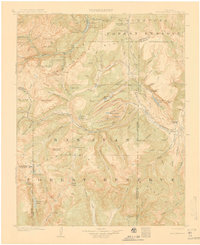
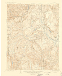
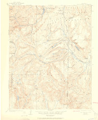
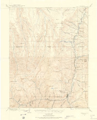
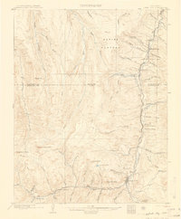
The Continental Divide forms the backbone of this high-altitude landscape, separating the headwaters of the Rio Grande from the Lake Fork Gunnison River. Recorded during the 1904–1905 survey, the region is dominated by two massive federal preserves, the Cochetopa Forest Reserve and the San Juan Forest Reserve. Mining-era settlements like Whitecross and Carson are visible alongside specialized landmarks such as Lakemans Fishponds and Burrows Park. High peaks including Rio Grande Pyramid and Redcloud Pk tower over the terrain, while travelers utilized Weminuche Pass to cross the divide. The map provides clear evidence of early water management and natural resource boundaries, including the Boundary Line between Hinsdale and Mineral counties and prominent water bodies like Lake San Cristobal.
Find a feature on this map
90 named features on this map. Tap any name to fly to it.
Don’t see what you’re looking for? This feature index may not catch every label — zoom into the map to look around manually.
Map Details
Editions of this 1907 San Cristobal Map
5 editions found


Other maps of this area

1897 · Silverton
USGS Topo · 1:62,500

1900 · Needle Mountains
USGS Topo · 1:62,500

1901 · Silverton
USGS Topo · 1:62,500

1902 · Needle Mountains
USGS Topo · 1:62,500

1902 · Silverton
USGS Topo · 1:62,500

1902 · Ouray
USGS Topo · 1:62,500
1903 · Lake City
USGS Topo · 1:62,500

1904 · Ouray
USGS Topo · 1:62,500
1905 · Lake City
USGS Topo · 1:62,500

1905 · San Cristobal
USGS Topo · 1:125,000