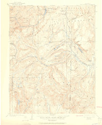
1907 Map of San Cristobal
USGS Topo · Published 1951About this map
High-altitude mining camps and the headwaters of the American West dominate this survey of the northern San Juan Mountains. Recorded by E.M. Douglas and J.F. McBeth shortly after the turn of the century, the map details a landscape where the Continental Divide dictates the flow of the Rio Grande and the Gunnison River. At the base of Sunshine Pk and Redcloud Pk, small settlements like Whitecross and Carson mark the era's mining activity. The geography is characterized by deep basins and glacial features, notably Lake San Cristobal and its small lakeside community at Lake Shore. This record preserves the early paths through the range, including the Lost Trail and the significant crossing at Weminuche Pass, before modern accessibility altered these remote Hinsdale County reaches.
Find a feature on this map
98 named features on this map. Tap any name to fly to it.
Don’t see what you’re looking for? This feature index may not catch every label — zoom into the map to look around manually.
Map Details
Editions of this 1907 San Cristobal Map
5 editions found

Other maps of this area

1897 · Silverton
USGS Topo · 1:62,500

1900 · Needle Mountains
USGS Topo · 1:62,500

1901 · Silverton
USGS Topo · 1:62,500

1902 · Needle Mountains
USGS Topo · 1:62,500

1902 · Silverton
USGS Topo · 1:62,500

1902 · Ouray
USGS Topo · 1:62,500

1903 · Lake City
USGS Topo · 1:62,500

1904 · Ouray
USGS Topo · 1:62,500

1905 · Lake City
USGS Topo · 1:62,500

1905 · San Cristobal
USGS Topo · 1:125,000