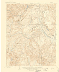
1907 Map of San Cristobal
USGS Topo · Published 1946About this map
The high alpine terrain of the San Juan Mountains dominates this early 20th-century survey, centered on the headwaters of the Lake Fork Gunnison River and the upper Rio Grande. In the northwest, the small mining-era settlements of Whitecross and Burrows sit deep in the gulches below Redcloud Pk and Sunshine Pk, reflecting a period when high-altitude mineral extraction shaped the local economy. The mapping of Lake San Cristobal and nearby Lakemans Fishponds highlights the area's hydrology at the turn of the century, prior to modern water management changes.
Find a feature on this map
86 named features on this map. Tap any name to fly to it.
Don’t see what you’re looking for? This feature index may not catch every label — zoom into the map to look around manually.
Map Details
Editions of this 1907 San Cristobal Map
5 editions found

Other maps of this area

1897 · Silverton
USGS Topo · 1:62,500

1900 · Needle Mountains
USGS Topo · 1:62,500

1901 · Silverton
USGS Topo · 1:62,500

1902 · Needle Mountains
USGS Topo · 1:62,500

1902 · Silverton
USGS Topo · 1:62,500

1902 · Ouray
USGS Topo · 1:62,500

1903 · Lake City
USGS Topo · 1:62,500

1904 · Ouray
USGS Topo · 1:62,500

1905 · Lake City
USGS Topo · 1:62,500

1905 · San Cristobal
USGS Topo · 1:125,000