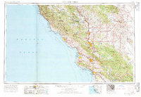
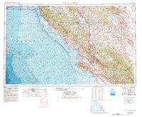
1956 Map of San Luis Obispo
USGS Topo · Published 1971About this map
The Santa Lucia Range and the Temblor Range frame a diverse landscape of coastal basins and interior valleys in this mid-century survey. The Southern Pacific RR serves as a primary north-south artery, connecting the regional hub of San Luis Obispo to agricultural and residential centers like Paso Robles, Atascadero, and Arroyo Grande. Along the rugged coastline, landmarks such as Hearst Castle and Mission San Miguel Arcangel reflect the area's deep architectural and cultural layers.
Find a feature on this map
116 named features on this map. Tap any name to fly to it.
Don’t see what you’re looking for? This feature index may not catch every label — zoom into the map to look around manually.
Map Details
Editions of this 1956 San Luis Obispo Map
5 editions found
Other maps of this area

1897 · Port Harford
USGS Topo · 1:62,500

1897 · San Luis Obispo
USGS Topo · 1:62,500

1897 · Cayucos
USGS Topo · 1:62,500

1897 · Arroyo Grande
USGS Topo · 1:62,500

1900 · San Luis
USGS Topo · 1:125,000

1902 · Santa Ynez
USGS Topo · 1:125,000

1905 · Guadalupe
USGS Topo · 1:125,000

1905 · Santa Ynez
USGS Topo · 1:125,000

1905 · Lompoc
USGS Topo · 1:125,000

1912 · Coalinga
USGS Topo · 1:125,000