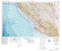
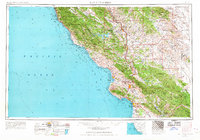
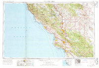
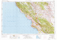
1956 Map of San Luis Obispo
USGS Topo · Published 1980About this map
Santa Lucia Range and the La Panza Range dominate this coastal survey, which highlights the rugged geography of the Central Coast before late-century development. The corridor between San Luis Obispo and Paso Robles follows the path of the Salinas River and the Southern Pacific RR, marking the primary artery for settlement and commerce. Along the coastline, the bathymetry added in 1979 reveals the seafloor topography of Estero Bay and San Luis Obispo Bay, while inland, the Carrizo Plain and Antelope Valley show a more arid, open landscape. Significant federal lands are represented, including Hunter Liggett Military Reservation and the Los Padres National Forest. Small coastal outposts like Cambria and San Simeon appear alongside established communities like Arroyo Grande and Santa Maria, illustrating the area's mix of agriculture, military presence, and emerging tourism.
Find a feature on this map
64 named features on this map. Tap any name to fly to it.
Don’t see what you’re looking for? This feature index may not catch every label — zoom into the map to look around manually.
Map Details
Editions of this 1956 San Luis Obispo Map
5 editions found

Other maps of this area

1897 · Port Harford
USGS Topo · 1:62,500

1897 · San Luis Obispo
USGS Topo · 1:62,500

1897 · Cayucos
USGS Topo · 1:62,500

1897 · Arroyo Grande
USGS Topo · 1:62,500

1900 · San Luis
USGS Topo · 1:125,000

1902 · Santa Ynez
USGS Topo · 1:125,000

1905 · Guadalupe
USGS Topo · 1:125,000

1905 · Santa Ynez
USGS Topo · 1:125,000

1905 · Lompoc
USGS Topo · 1:125,000

1912 · Coalinga
USGS Topo · 1:125,000