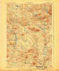
1923 Map of Santa Clara
USGS Topo · Published 1923About this map
Santa Clara stands at the center of this 1920s landscape, where the lumber industry and early Adirondack tourism intersect. The Brooklyn Cooperage RR snakes through the western terrain, following the course of the St. Regis River and passing by industrial-era sites like Everton. This network of rails and primitive roads, including the Brooklyn Road and Northwest Bay Road, highlights a period when timber extraction was the primary economic driver of Franklin County.
Find a feature on this map
113 named features on this map. Tap any name to fly to it.
Don’t see what you’re looking for? This feature index may not catch every label — zoom into the map to look around manually.
Map Details
Editions of this 1923 Santa Clara Map
5 editions found

Other maps of this area

1902 · Saranac
USGS Topo · 1:62,500

1904 · Saranac
USGS Topo · 1:62,500

1905 · Saint Regis
USGS Topo · 1:62,500

1906 · Loon Lake
USGS Topo · 1:62,500

1908 · Loon Lake
USGS Topo · 1:62,500

1915 · Chateaugay
USGS Topo · 1:62,500

1915 · Malone
USGS Topo · 1:62,500

1915 · Moira
USGS Topo · 1:62,500

1917 · Malone
USGS Topo · 1:62,500

1917 · Moira
USGS Topo · 1:62,500