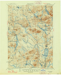
1923 Map of Santa Clara
USGS Topo · Published 1947About this map
Santa Clara and the surrounding Adirondack wilderness define this early twentieth-century landscape, a territory where industrial timber and transit once dominated. The shifting nature of North Country infrastructure is evident in the New York Central Railroad (Abandoned) and the Brooklyn Cooperage RR, which served the region's logging and manufacturing interests. Settlement patterns are concentrated at isolated outposts such as Reynoldston, Gile, and Madawaska, while local life is further anchored by a network of rural schools like School No 5 and the McCollom School.
Find a feature on this map
118 named features on this map. Tap any name to fly to it.
Don’t see what you’re looking for? This feature index may not catch every label — zoom into the map to look around manually.
Map Details
Editions of this 1923 Santa Clara Map
5 editions found

Other maps of this area

1902 · Saranac
USGS Topo · 1:62,500

1904 · Saranac
USGS Topo · 1:62,500

1905 · Saint Regis
USGS Topo · 1:62,500

1906 · Loon Lake
USGS Topo · 1:62,500

1908 · Loon Lake
USGS Topo · 1:62,500

1915 · Chateaugay
USGS Topo · 1:62,500

1915 · Malone
USGS Topo · 1:62,500

1915 · Moira
USGS Topo · 1:62,500

1917 · Malone
USGS Topo · 1:62,500

1917 · Moira
USGS Topo · 1:62,500