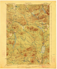
1923 Map of Santa Clara
USGS Topo · Published 1923This historical map portrays the area of Santa Clara in 1923, primarily covering Franklin County. Featuring a scale of 1:62500, this map provides a highly detailed snapshot of the terrain, roads, buildings, counties, and historical landmarks in the Santa Clara region at the time. Published in 1923, it is one of 5 known editions of this map due to revisions or reprints.
Find a feature on this map
111 named features on this map. Tap any name to fly to it.
Don’t see what you’re looking for? This feature index may not catch every label — zoom into the map to look around manually.
Map Details
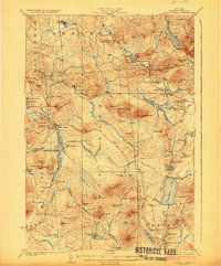
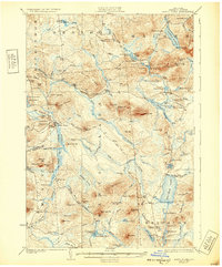
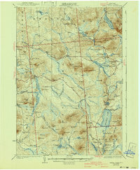
Editions of this 1923 Santa Clara Map
5 editions found
Historical Maps of Madawaska Through Time
60 maps found

1902 Saranac
Franklin County, NY

1904 Long Lake
Franklin County, NY

1904 Saranac
Franklin County, NY

1905 Saint Regis
Franklin County, NY

1906 Loon Lake
Franklin County, NY

1908 Loon Lake
Franklin County, NY

1915 Chateaugay
Franklin County, NY

1915 Malone
Franklin County, NY

1915 Moira
Franklin County, NY

1917 Malone
Franklin County, NY

1917 Moira
Franklin County, NY

1921 Santa Clara
Franklin County, NY

1923 Santa Clara
Franklin County, NY

1943 Chateaugay
Franklin County, NY

1944 Moira
Franklin County, NY

1955 Long Lake
Franklin County, NY

1955 Saint Regis
Franklin County, NY

1964 Bangor
Franklin County, NY

1964 Bombay
Franklin County, NY

1964 Brainardsville
Franklin County, NY

1964 Burke
Franklin County, NY

1964 Chasm Falls
Franklin County, NY

1964 Chateaugay
Franklin County, NY

1964 Constable
Franklin County, NY

1964 Ft. Covington
Franklin County, NY

1964 Lake Ozonia
Franklin County, NY

1964 Lake Titus
Franklin County, NY

1964 Malone
Franklin County, NY

1964 Meacham Lake
Franklin County, NY

1964 Meno
Franklin County, NY

1964 Saint Regis Falls
Franklin County, NY

1964 Santa Clara
Franklin County, NY

1968 Alder Brook
Franklin County, NY

1968 Debar Mountain
Franklin County, NY

1968 Loon Lake
Franklin County, NY

1968 Owls Head
Franklin County, NY

1968 Ragged Lake
Franklin County, NY

1970 Augerhole Falls
Franklin County, NY

1977 Chateaugay Port of Entry
Franklin County, NY

1977 East of Fort Covington Port of Entry
Franklin County, NY

1977 Fort Covington Port of Entry
Franklin County, NY

1977 Jamiesons Line Station
Franklin County, NY

1977 Massena Port of Entry
Franklin County, NY

1977 Trout River Port of Entry
Franklin County, NY

1978 Ampersand Lake
Franklin County, NY

1978 Bloomingdale
Franklin County, NY

1979 Saint Regis Mtn
Franklin County, NY

1979 Tupper Lake
Franklin County, NY

1979 Upper Saranac Lake
Franklin County, NY

1985 Massena
Franklin County, NY

1993 Burke
Franklin County, NY

1993 Chateaugay
Franklin County, NY

1993 Constable
Franklin County, NY

1993 Fort Covington
Franklin County, NY

1994 Massena
Franklin County, NY

1999 Ampersand Lake
Franklin County, NY

1999 Bloomingdale
Franklin County, NY

1999 Saint Regis Mtn.
Franklin County, NY

1999 Tupper Lake
Franklin County, NY

1999 Upper Saranac Lake
Franklin County, NY