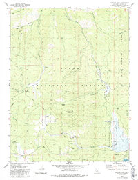
1981 Map of Sardine Peak
USGS Topo · Published 1987About this map
Sardine Peak (Lookout) serves as a primary high-altitude vantage point within the Tahoe National Forest, overlooking a complex terrain of canyons and flats in the eastern Sierra Nevada. The 1981 survey reveals a landscape shaped by seasonal agricultural use and early transportation routes, including the Henness Pass Road which skirts the southern edge of the quadrangle. High-country activity is evident at sites such as Wheelers Sheep Camp and Henness Corral, suggesting the area's continued role for livestock grazing. The drainage network is well-defined, with Smithneck Creek and Bear Valley Creek carving through the Bald Mountain Range. At lower elevations, the presence of the Stampede Res and the Lewis Mill Station indicates the convergence of water management and historical station points that anchored this mountain economy during the late 20th century.
Find a feature on this map
37 named features on this map. Tap any name to fly to it.
Don’t see what you’re looking for? This feature index may not catch every label — zoom into the map to look around manually.
Map Details
Editions of this 1981 Sardine Peak Map
3 editions found
Other maps of this area

1890 · Sierraville
USGS Topo · 1:125,000

1891 · Truckee
USGS Topo · 1:125,000

1892 · Sierraville
USGS Topo · 1:125,000

1893 · Truckee
USGS Topo · 1:125,000

1894 · Sierraville
USGS Topo · 1:125,000

1895 · Truckee
USGS Topo · 1:125,000

1932 · Truckee
USGS Topo · 1:96,000

1940 · Truckee
USGS Topo · 1:125,000

1955 · Loyalton
USGS Topo · 1:62,500
1955 · Donner Pass
USGS Topo · 1:62,500