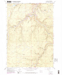
1961 Map of Savoy
USGS Topo · Published 1979About this map
Black Hills National Forest land dominates this 1961 survey, revealing a landscape defined by dramatic gulches and vital water sources in the high country. The small settlement of Savoy serves as a central point near the impressive Spearfish Falls and Roughlock Falls, where the canyon terrain dictates the placement of early infrastructure like the Aqueduct lines. Further south, the high Limestone Plateau is dotted with uniquely named springs, such as What the Hell Spring and Dead Oz Spring, which provided essential water in this high-elevation terrain. Local history is etched into the map through locations like the Little Spearfish Guard Station and established campsites such as the Rod and Gun Campground, alongside the more isolated settlements of Preston and Elmore and a small mountain Cemetery near Long Valley.
Find a feature on this map
47 named features on this map. Tap any name to fly to it.
Don’t see what you’re looking for? This feature index may not catch every label — zoom into the map to look around manually.
Map Details
Editions of this 1961 Savoy Map
4 editions found
Other maps of this area

1894 · Deadwood
USGS Topo · 1:125,000

1898 · Sundance
USGS Topo · 1:125,000

1900 · Spearfish
USGS Topo · 1:62,500

1901 · Deadwood
USGS Topo · 1:125,000

1902 · Sundance
USGS Topo · 1:125,000

1915 · Spearfish
USGS Topo · 1:62,500

1916 · Deadwood
USGS Topo · 1:125,000

1953 · Rapid City
USGS Topo · 1:250,000

1954 · Gillette
USGS Topo · 1:250,000

1955 · Gillette
USGS Topo · 1:250,000