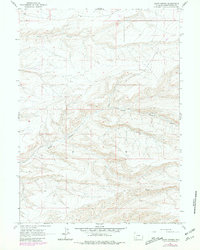
1961 Map of Scott Spring
USGS Topo · Published 1981About this map
Scott Canyon and Skunk Canyon dominate this high-desert landscape in Sweetwater County, where the topography is defined by the steep-walled drainages of the Green River basin. The area's mid-century utility infrastructure is visible through a prominent Pipeline that cuts across the northern ridges and a small electrical Substa near the northern boundary. Centered on the water source at Scott Spring, the map illustrates a transition from the original 1961 field survey to late-1970s updates. These revisions, shown in purple, reveal shifts in unimproved roads and minor land alterations that occurred between the initial mapping and the 1980 photorevision. The scarcity of permanent structures reflects the isolated character of this region, focusing instead on the intersection of Township and Range lines such as T. 20 N. T. 19 N. and R. 107 W. R. 106 W. that govern land management in the Wyoming backcountry.
Find a feature on this map
8 named features on this map. Tap any name to fly to it.
Don’t see what you’re looking for? This feature index may not catch every label — zoom into the map to look around manually.
Map Details
Editions of this 1961 Scott Spring Map
2 editions found
Other maps of this area

1954 · Rock Springs
USGS Topo · 1:250,000

1958 · Rock Springs
USGS Topo · 1:250,000

1961 · Scott Spring
USGS Topo · 1:24,000

1961 · Peru
USGS Topo · 1:24,000

1961 · Pilot Butte
USGS Topo · 1:24,000

1961 · Austin Ranch
USGS Topo · 1:24,000

1961 · Kanda
USGS Topo · 1:24,000

1961 · Green River
USGS Topo · 1:24,000

1962 · Rock Springs
USGS Topo · 1:250,000
1963 · Chrisman Ranch
USGS Topo · 1:24,000