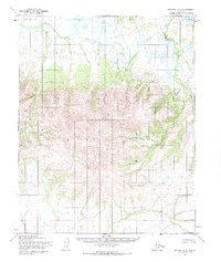
1955 Map of Selawik A-3
USGS Topo · Published 1968About this map
The Selawik Hills dominate this portion of the Northwest Arctic, where the terrain transitions from the elevated interior to the meandering drainage basins of the north. Photogrammetric methods capture the complex hydrology of the region, including the winding course of the Kauk River and the Maryuuk River. These waterways, along with Lomen Creek, illustrate the natural drainage patterns of an unsurveyed landscape as it was documented in the mid-1950s. The map represents a significant effort by the Army Map Service to document the Kateel River Meridian, showing predetermined but unmarked land lines that reflect the administrative challenges of managing this immense northern territory.
Find a feature on this map
4 named features on this map. Tap any name to fly to it.
Don’t see what you’re looking for? This feature index may not catch every label — zoom into the map to look around manually.
Map Details
Editions of this 1955 Selawik A-3 Map
2 editions found
Other maps of this area

1951 · Candle
USGS Topo · 1:250,000

1951 · Selawik
USGS Topo · 1:250,000

1954 · Candle D-2
USGS Topo · 1:63,360

1955 · Candle
USGS Topo · 1:250,000

1955 · Selawik A-4
USGS Topo · 1:63,360

1955 · Candle D-4
USGS Topo · 1:63,360

1955 · Selawik B-3
USGS Topo · 1:63,360
1955 · Candle D-3
USGS Topo · 1:63,360

1955 · Selawik A-3
USGS Topo · 1:63,360

1955 · Selawik B-4
USGS Topo · 1:63,360