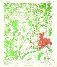
1958 Map of Selma
USGS Topo · Published 1964About this map
Selma stands as a dense urban hub along the north bank of the Alabama River, where the rail lines of the Southern and Louisville and Nashville railroads converge. The city’s mid-century landscape is defined by an extensive network of educational and religious institutions, ranging from Selma University and Alabama Academy to numerous neighborhood schools like Hudson High Sch and Knox Sch. The river’s prominent Kings Bend shapes the southern boundary, where the Gaging Station and Waterworks anchor the local infrastructure. Beyond the city center, the terrain transitions into a mosaic of rural communities and family-named landmarks. The historic Live Oak Cem and New Live Oak Cem occupy significant acreage near the river, while outlying settlements like Selmont and Potter are connected by a web of creeks including Oakmulgee Creek and Childers Creek. The map meticulously records the civic heart of the area, including City Hall, Memorial Stadium, and the Selma Country Club.
Find a feature on this map
72 named features on this map. Tap any name to fly to it.
Don’t see what you’re looking for? This feature index may not catch every label — zoom into the map to look around manually.
Map Details
Editions of this 1958 Selma Map
3 editions found
Other maps of this area

1891 · Clanton
USGS Topo · 1:125,000

1953 · Montgomery
USGS Topo · 1:250,000

1956 · Montgomery
USGS Topo · 1:250,000

1957 · Montgomery
USGS Topo · 1:250,000

1957 · Benton
USGS Topo · 1:62,500

1958 · Selma
USGS Topo · 1:62,500

1958 · Selma
USGS Topo · 1:24,000

1959 · Plantersville
USGS Topo · 1:62,500

1959 · Summerfield
USGS Topo · 1:62,500

1975 · Selma NW
USGS Topo · 1:24,000