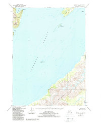
1951 Map of Seward A-2
USGS Topo · Published 1988About this map
Montague Strait dominates this maritime survey, carving a deep-water passage between the massive eastern shores of Montague Island and the jagged southern reach of Knight Island. Based on 1951 aerial photography with revisions through the 1980s, the map documents a largely unsettled coastal wilderness within the Chugach National Forest. Evidence of human activity is scarce, marked only by a lone Cabin on the southern island's eastern flank. The complex coastline is defined by features like Snug Harbor and Hogan Bay, while smaller landmasses such as Green Island and Little Green Island dot the strait. Significant elevations are noted at Horn Mountain, providing a stark contrast to the charted depths and submerged hazards like The Needle that dictate navigation in these cold Alaskan waters.
Find a feature on this map
21 named features on this map. Tap any name to fly to it.
Don’t see what you’re looking for? This feature index may not catch every label — zoom into the map to look around manually.
Map Details
Editions of this 1951 Seward A-2 Map
3 editions found
Other maps of this area

1946 · Blying Sound
USGS Topo · 1:250,000

1950 · Seward B-3
USGS Topo · 1:63,360

1951 · Blying Sound
USGS Topo · 1:250,000

1951 · Seward
USGS Topo · 1:250,000

1951 · Seward B-1
USGS Topo · 1:63,360

1951 · Seward A-2
USGS Topo · 1:63,360

1951 · Seward A-3
USGS Topo · 1:63,360

1951 · Blying Sound D-1 and D-2
USGS Topo · 1:63,360

1951 · Seward A-1
USGS Topo · 1:63,360

1951 · Seward B-2
USGS Topo · 1:63,360