
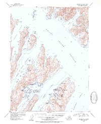
1952 Map of Seward A-3
USGS Topo · Published 1954About this map
Latouche Island serves as the industrial and maritime anchor of this 1950s coastal survey, depicting a period of transition in the Prince of Wales Passage. The settlement of Latouche is established on the island's western shore, positioned near a cluster of resource-extraction sites including the Beatson Mine (Aband) and Blackbird Mine (Aband). These locations, along with the nearby Girdwood (Aband), reflect the boom-and-bust cycle of early twentieth-century mining in the region. Across the water on Evans Island, the San Juan Cannery and Port Ashton highlight the importance of the commercial fishing industry during this era.
Find a feature on this map
68 named features on this map. Tap any name to fly to it.
Don’t see what you’re looking for? This feature index may not catch every label — zoom into the map to look around manually.
Map Details
Editions of this 1952 Seward A-3 Map
2 editions found
Other maps of this area

1946 · Blying Sound
USGS Topo · 1:250,000

1950 · Seward B-3
USGS Topo · 1:63,360

1950 · Blying Sound D-4
USGS Topo · 1:63,360

1951 · Blying Sound
USGS Topo · 1:250,000

1951 · Seward
USGS Topo · 1:250,000

1951 · Seward A-2
USGS Topo · 1:63,360

1951 · Seward B-4
USGS Topo · 1:63,360

1951 · Seward A-3
USGS Topo · 1:63,360

1951 · Blying Sound D-1 and D-2
USGS Topo · 1:63,360

1951 · Seward A-4
USGS Topo · 1:63,360