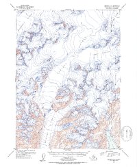
1952 Map of Seward A-5
USGS Topo · Published 1954About this map
The Sargent Ice Field dominates this 1952 topographic study, illustrating the glacial systems of the Kenai Peninsula before late-century retreat. Massive ice flows including Ellsworth Glacier, Tiger Glacier, and Chenega Glacier are documented with precise contour work and notations of extensive crevasses. The map captures the meeting of land and sea where the Puget Glacier descends toward Puget Bay within the eastern portion of the Chugach National Forest. A singular landmark, Pinnacle Mountain, rises above the surrounding ice and technical terrain. This survey, compiled from 1950 aerial photography and 1952 multiplex methods, provides a baseline for glaciologists and historical researchers studying the coastal geography of the Alaska-Third Judicial Division during the mid-20th century.
Find a feature on this map
11 named features on this map. Tap any name to fly to it.
Don’t see what you’re looking for? This feature index may not catch every label — zoom into the map to look around manually.
Map Details
Editions of this 1952 Seward A-5 Map
2 editions found

Other maps of this area

1946 · Blying Sound
USGS Topo · 1:250,000

1950 · Seward A-6
USGS Topo · 1:63,360

1950 · Blying Sound D-6
USGS Topo · 1:63,360

1950 · Blying Sound D-4
USGS Topo · 1:63,360

1950 · Blying Sound D-5
USGS Topo · 1:63,360

1951 · Blying Sound
USGS Topo · 1:250,000

1951 · Seward
USGS Topo · 1:250,000

1951 · Seward A-6
USGS Topo · 1:63,360

1951 · Seward B-4
USGS Topo · 1:63,360

1951 · Seward A-5
USGS Topo · 1:63,360