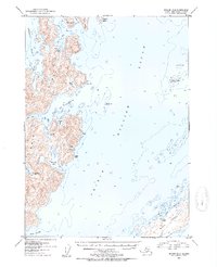
1952 Map of Seward B-2
USGS Topo · Published 1954About this map
The complex shoreline of Knight Island dominates this mid-century survey of the central Prince William Sound. The map documents a rugged landscape within the Chugach National Forest, characterized by deep inlets such as Herring Bay and the Bay of Isles. On the eastern shore of Knight Island, the presence of a Mine (Abn) near Rua Cove points to the area's early 20th-century prospecting history, while several Cabins and tidal benchmarks like BM (Tidal) 3 indicate pockets of activity along the coast. To the southeast, Green Island provides a natural buffer for Gibbon Anchorage, a key refuge for maritime traffic. Numerous small landforms, including Disk Island and Seal I, are meticulously charted alongside bathymetric soundings, illustrating the navigational hazards and sheltered waters of Snug Harbor and Lower Passage before the landscape was altered by later seismic activity.
Find a feature on this map
32 named features on this map. Tap any name to fly to it.
Don’t see what you’re looking for? This feature index may not catch every label — zoom into the map to look around manually.
Map Details
Editions of this 1952 Seward B-2 Map
2 editions found

Other maps of this area

1950 · Seward B-3
USGS Topo · 1:63,360

1951 · Seward
USGS Topo · 1:250,000

1951 · Seward B-1
USGS Topo · 1:63,360

1951 · Seward A-2
USGS Topo · 1:63,360

1951 · Seward A-3
USGS Topo · 1:63,360

1951 · Seward A-1
USGS Topo · 1:63,360

1951 · Seward B-2
USGS Topo · 1:63,360

1951 · Seward C-1
USGS Topo · 1:63,360

1951 · Seward C-3
USGS Topo · 1:63,360

1951 · Seward C-2
USGS Topo · 1:63,360