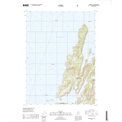
2018 Map of Seward B-3 NE
USGS Topo · Published 2018About this map
Prince William Sound defines this coastal landscape, where the tides of the Gulf of Alaska reach into deep, protected inlets. This 2018 survey emphasizes the maritime and wilderness character of the region, dominated by the mountainous terrain of the Chugach National Forest. The map documents a complex coastline of bays and narrows, notably Herring Bay and its southern counterpart, Lower Herring Bay, which are separated from the West Arm Bay of Isles by high, ridged land. Navigational landmarks such as Channel Rock and Herring Point serve as the primary reference points for this uninhabited stretch of the Alaskan coast. The absence of roads or permanent settlements underscores the area's preservation as a protected forest environment, where the topographic detail reveals the intricate interplay between steep shoreline elevations and the surrounding waters.
Find a feature on this map
15 named features on this map. Tap any name to fly to it.
Don’t see what you’re looking for? This feature index may not catch every label — zoom into the map to look around manually.
Map Details
Editions of this 2018 Seward B-3 NE Map
This is the sole edition of this map. No revisions or reprints were ever made.
Other maps of this area

1950 · Seward B-3
USGS Topo · 1:63,360

1951 · Seward
USGS Topo · 1:250,000

1951 · Seward B-2
USGS Topo · 1:63,360

1951 · Seward C-3
USGS Topo · 1:63,360

1951 · Seward C-2
USGS Topo · 1:63,360

1952 · Seward B-3
USGS Topo · 1:63,360

1952 · Seward C-3
USGS Topo · 1:63,360

1952 · Seward B-2
USGS Topo · 1:63,360

1952 · Seward C-2
USGS Topo · 1:63,360

1953 · Seward
USGS Topo · 1:250,000