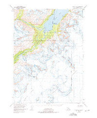
1951 Map of Seward B-5
USGS Topo · Published 1975About this map
Sargent Ice Field dominates the southern reaches of this mid-century survey, a frozen expanse that feeds several prominent glaciers and river systems across the Kenai Peninsula. Flowing from these high ice masses, the Ellsworth Glacier and Langdon Glacier move through the central landscape, while the Nellie Juan River carves a path toward the north. This environment within the Chugach National Forest is defined by its dramatic hydrography, where the Kings River empties into the tidal waters of Kings Bay. Small landmarks like Kings Point and Kings Glacier illustrate the local nomenclature of the region, while VABM peaks such as Baker, Dream, and Acorn provide specific survey points amidst the shifting ice and terminal moraines. The map reflects a period of meticulous photogrammetric mapping before modern satellite imagery, capturing the precise extent of glaciers like Applegate Glacier and Falling Glacier as they stood in 1951.
Find a feature on this map
23 named features on this map. Tap any name to fly to it.
Don’t see what you’re looking for? This feature index may not catch every label — zoom into the map to look around manually.
Map Details
Editions of this 1951 Seward B-5 Map
2 editions found
Other maps of this area

1950 · Seward A-6
USGS Topo · 1:63,360

1951 · Seward
USGS Topo · 1:250,000

1951 · Seward A-6
USGS Topo · 1:63,360

1951 · Seward C-6
USGS Topo · 1:63,360

1951 · Seward B-4
USGS Topo · 1:63,360

1951 · Seward C-5
USGS Topo · 1:63,360

1951 · Seward A-5
USGS Topo · 1:63,360

1951 · Seward B-6
USGS Topo · 1:63,360

1951 · Seward B-5
USGS Topo · 1:63,360

1951 · Seward A-4
USGS Topo · 1:63,360