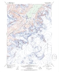
1952 Map of Seward B-5
USGS Topo · Published 1954About this map
Sargent Ice Field dominates the southern landscape of this mid-century survey, its massive expanse of ice punctuated by numerous crevasses as it flows into the Ellsworth Glacier. This environment within the Chugach National Forest is defined by high-altitude glacial movement and dramatic elevation changes. In the north, Kings Bay provides a marine terminus for several alpine ice flows, including the Langdon Glacier and Kings Glacier.
Find a feature on this map
14 named features on this map. Tap any name to fly to it.
Don’t see what you’re looking for? This feature index may not catch every label — zoom into the map to look around manually.
Map Details
Editions of this 1952 Seward B-5 Map
2 editions found

Other maps of this area

1950 · Seward A-6
USGS Topo · 1:63,360

1951 · Seward
USGS Topo · 1:250,000

1951 · Seward A-6
USGS Topo · 1:63,360

1951 · Seward C-6
USGS Topo · 1:63,360

1951 · Seward B-4
USGS Topo · 1:63,360

1951 · Seward C-5
USGS Topo · 1:63,360

1951 · Seward A-5
USGS Topo · 1:63,360

1951 · Seward B-6
USGS Topo · 1:63,360

1951 · Seward B-5
USGS Topo · 1:63,360

1951 · Seward A-4
USGS Topo · 1:63,360