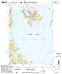
1995 Map of Seward C-3
USGS Topo · Published 1999About this map
Perry Island and the surrounding reaches of Prince William Sound anchor this mid-1990s maritime survey, revealing a landscape defined by industrial fishing and protected coastal reserves. Along the southern shores, the Fish Hatchery (State) and a nearby Boat Ramp on Main Bay signal the active management of the region's aquatic resources. Evidence of shifting coastal industry appears on Perry Island, where a Private Fish Farm (Inactive) is noted near South Bay, while the Lighthouse Reserve marks a significant navigational footprint to the southwest.
Find a feature on this map
30 named features on this map. Tap any name to fly to it.
Don’t see what you’re looking for? This feature index may not catch every label — zoom into the map to look around manually.
Map Details
Editions of this 1995 Seward C-3 Map
This is the sole edition of this map. No revisions or reprints were ever made.
Other maps of this area

1950 · Seward B-3
USGS Topo · 1:63,360

1951 · Seward
USGS Topo · 1:250,000

1951 · Seward B-4
USGS Topo · 1:63,360

1951 · Seward D-2
USGS Topo · 1:63,360

1951 · Seward D-4
USGS Topo · 1:63,360

1951 · Seward B-2
USGS Topo · 1:63,360

1951 · Seward D-3
USGS Topo · 1:63,360

1951 · Seward C-4
USGS Topo · 1:63,360

1951 · Seward C-3
USGS Topo · 1:63,360

1951 · Seward C-2
USGS Topo · 1:63,360