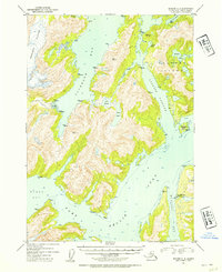
1952 Map of Seward C-4
USGS Topo · Published 1954About this map
Port Nellie Juan Cannery serves as the primary coastal outpost in this 1952 topographic study of Prince William Sound's intricate shoreline. The landscape is dominated by the massive Tebenkof Glacier to the northwest, which feeds into the deep waters of Cochrane Bay. Settlement is sparse and maritime-focused, centered around the seasonal activity of the cannery and the protected harbors of Port Nellie Juan.
Find a feature on this map
53 named features on this map. Tap any name to fly to it.
Don’t see what you’re looking for? This feature index may not catch every label — zoom into the map to look around manually.
Map Details
Editions of this 1952 Seward C-4 Map
2 editions found

Other maps of this area

1950 · Seward B-3
USGS Topo · 1:63,360

1951 · Seward
USGS Topo · 1:250,000

1951 · Seward D-5
USGS Topo · 1:63,360

1951 · Seward B-4
USGS Topo · 1:63,360

1951 · Seward C-5
USGS Topo · 1:63,360

1951 · Seward D-4
USGS Topo · 1:63,360

1951 · Seward B-5
USGS Topo · 1:63,360

1951 · Seward D-3
USGS Topo · 1:63,360

1951 · Seward C-4
USGS Topo · 1:63,360

1951 · Seward C-3
USGS Topo · 1:63,360