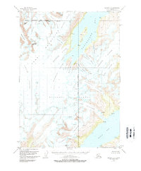
1951 Map of Seward C-5
USGS Topo · Published 1970About this map
The Kenai Mountains define this icy landscape, where a massive system of glaciers descends into the deep waters of Blackstone Bay and Kings Bay. Within the Chugach National Forest, the map records an environment dominated by moving ice and high peaks like Carpathian Peak and Byron Peak. The convergence of the Greater Anchorage Area Borough and Kenai Peninsula Borough boundaries cuts across these frozen fields, highlighting the remote nature of the terrain in the early 1950s. Dozens of glaciers are named, including the expansive Spencer Glacier and Northland Glacier, many of which are marked with numerous crevasses, indicating the active state of the ice at the time of the 1950 aerial survey. Small survey markers like VABM Heart and VABM Liver on Willard Island provide unique points of reference for those tracing historical cartographic and maritime surveying efforts in the region.
Find a feature on this map
43 named features on this map. Tap any name to fly to it.
Don’t see what you’re looking for? This feature index may not catch every label — zoom into the map to look around manually.
Map Details
Editions of this 1951 Seward C-5 Map
4 editions found
Other maps of this area

1951 · Seward
USGS Topo · 1:250,000

1951 · Seward C-6
USGS Topo · 1:63,360

1951 · Seward D-5
USGS Topo · 1:63,360

1951 · Seward B-4
USGS Topo · 1:63,360

1951 · Seward C-5
USGS Topo · 1:63,360

1951 · Seward D-4
USGS Topo · 1:63,360

1951 · Seward B-6
USGS Topo · 1:63,360

1951 · Seward B-5
USGS Topo · 1:63,360

1951 · Seward C-4
USGS Topo · 1:63,360

1951 · Seward D-6
USGS Topo · 1:63,360