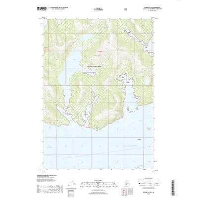
2018 Map of Seward D-3 SW
USGS Topo · Published 2018About this map
Esther Island dominates this maritime landscape within the Chugach National Forest, featuring a complex coastline of deep coves and glacial-carved topography. The interior of the island is marked by Esther Lake, a significant body of water positioned between steep-sided peaks. The surrounding waters of Prince William Sound are punctuated by landforms such as Hodgkins Point and Point Perry, which delineate the entrances to protected harbor areas. This chart illustrates a pristine environment where land and sea are intricately linked, with sheltered inlets like Quillian Bay and Lake Bay providing refuge from the open reaches of Wells Passage. The presence of small maritime hazards like Egg Rocks and narrow passages such as Shoestring Cove highlights the specialized navigation required in this part of the Alaskan wilderness.
Find a feature on this map
19 named features on this map. Tap any name to fly to it.
Don’t see what you’re looking for? This feature index may not catch every label — zoom into the map to look around manually.
Map Details
Editions of this 2018 Seward D-3 SW Map
This is the sole edition of this map. No revisions or reprints were ever made.
Other maps of this area

1951 · Seward
USGS Topo · 1:250,000

1951 · Seward D-4
USGS Topo · 1:63,360

1951 · Seward D-3
USGS Topo · 1:63,360

1951 · Seward C-4
USGS Topo · 1:63,360

1951 · Seward C-3
USGS Topo · 1:63,360

1952 · Seward D-3
USGS Topo · 1:63,360

1952 · Seward C-3
USGS Topo · 1:63,360

1952 · Seward D-4
USGS Topo · 1:63,360

1952 · Seward C-4
USGS Topo · 1:63,360

1953 · Seward
USGS Topo · 1:250,000