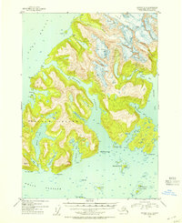
1952 Map of Seward D-3
USGS Topo · Published 1964About this map
Esther Island and the surrounding waters of Prince William Sound define this coastal survey within the Chugach National Forest. The landscape is dominated by the massive ice flows of Crescent Glacier, Tommy Glacier, and Eaglek Glacier feeding into the northern bays. Human activity is sparse, marked primarily by the site of Golden (Aban'd) on the northwestern shore and scattered Cabins near the Avery River. Navigation across Esther Passage and Wells Passage is supported by the Esther Island Light and a NOAA Radio Range Sta located on a small islet to the east. The intricate shoreline features numerous protected anchorages such as Shoestring Cove, Quillian Bay, and Papoose Cove, illustrating the maritime-dependent nature of the region during the mid-20th century.
Find a feature on this map
33 named features on this map. Tap any name to fly to it.
Don’t see what you’re looking for? This feature index may not catch every label — zoom into the map to look around manually.
Map Details
Editions of this 1952 Seward D-3 Map
2 editions found
Other maps of this area

1951 · Seward
USGS Topo · 1:250,000

1951 · Anchorage
USGS Topo · 1:250,000

1951 · Seward D-2
USGS Topo · 1:63,360

1951 · Seward D-4
USGS Topo · 1:63,360

1951 · Seward D-3
USGS Topo · 1:63,360

1951 · Seward C-4
USGS Topo · 1:63,360

1951 · Seward C-3
USGS Topo · 1:63,360

1951 · Seward C-2
USGS Topo · 1:63,360

1952 · Seward D-3
USGS Topo · 1:63,360

1952 · Seward C-3
USGS Topo · 1:63,360