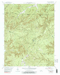
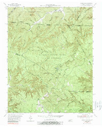
1955 Map of Sharp Place
USGS Topo · Published 1989About this map
Sharp Place sits at the heart of this mid-century survey, surrounded by the heavily dissected terrain of the Upper Cumberland plateau. The landscape is defined by the expansive Pickett State Park and Forest and the Cumberland National Forest, where natural landmarks like Natural Bridge, Hazard Cave, and the distinctive Chimney Rock highlight the region's unique geology. This period shows a rural community structure centered on localized gathering points such as Akers Chapel and educational sites like Langham Sch and Sharp Sch. The map reveals a complex drainage network including the South Fork and Rock Creek, where many deep hollows and branches take their names from local families. Notable geologic features such as Yellow Cliff and Greenwood Cliff flank the winding watercourses, illustrating the geological character that historically shaped settlement patterns and road placements in this part of Fentress and Pickett counties.
Find a feature on this map
76 named features on this map. Tap any name to fly to it.
Don’t see what you’re looking for? This feature index may not catch every label — zoom into the map to look around manually.
Map Details
Editions of this 1955 Sharp Place Map
5 editions found
Other maps of this area

1895 · Wartburg
USGS Topo · 1:125,000

1896 · Wartburg
USGS Topo · 1:125,000

1934 · Barthell
USGS Topo · 1:62,500

1934 · Pall Mall
USGS Topo · 1:62,500

1952 · Honey Creek
USGS Topo · 1:24,000

1954 · Stockton
USGS Topo · 1:24,000

1954 · Parmleysville
USGS Topo · 1:24,000

1954 · Jamestown
USGS Topo · 1:24,000

1954 · Powersburg
USGS Topo · 1:24,000

1954 · Bell Farm
USGS Topo · 1:24,000