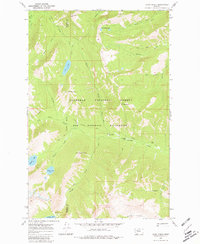
1970 Map of Shaw Creek
USGS Topo · Published 1980About this map
The boundary between Missoula County and Powell County cuts through this high-altitude landscape within the Bob Marshall Wilderness and Flathead National Forest. This 1970 field-checked survey reveals a backcountry defined by steep peaks and drainage basins, where the Shaw Creek Guard Sta serves as a remote outpost for forest management. A sophisticated network of pack and foot trails, including the Holland Gordon Trail, connects the mountain ridges to significant alpine waters like Lena Lake, Doctor Lake, and George Lake. The topography is shaped by the headwaters of Big Salmon Creek and Shaw Creek, with the highest points at Lena Peak and Shaw Mountain providing vantage points over the Big Knife Lakes. The map documents a period before modern infrastructure reached these interior ranges, preserving the original trail routes and surveyor markers.
Find a feature on this map
29 named features on this map. Tap any name to fly to it.
Don’t see what you’re looking for? This feature index may not catch every label — zoom into the map to look around manually.
Map Details
Editions of this 1970 Shaw Creek Map
3 editions found
Other maps of this area

1902 · Ovando
USGS Topo · 1:125,000

1905 · Ovando
USGS Topo · 1:125,000

1921 · Elbow Lake
USGS Topo · 1:125,000

1936 · Silvertip
USGS Topo · 1:96,000

1942 · Silvertip
USGS Topo · 1:125,000

1955 · Choteau
USGS Topo · 1:250,000

1957 · Choteau
USGS Topo · 1:250,000

1958 · Choteau
USGS Topo · 1:250,000

1962 · Choteau
USGS Topo · 1:250,000

1965 · Holland Lake
USGS Topo · 1:24,000