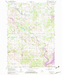
1964 Map of Sherman City
USGS Topo · Published 1983About this map
The Chippewa River and Coldwater River converge in this central Michigan landscape, defining a region where rural crossroads and small water bodies shape the settlement pattern. At the intersection of the Mecosta and Isabella county line, Sherman City serves as a local focal point alongside several smaller hamlets such as Horr, Titus, and Drew. The map documents a classic Midwestern agricultural and recreation landscape, dotted with numerous lakes including the cluster known as Six Lakes, which includes Strong Lake, Market Lake, and Long Lake. Genealogists will find notable value in the location of the Strong Cemetery and Sherman City Cemetery, as well as the Forest Hill Church along the Weidman Forest Hill Ch Road. Resource extraction and light aviation are evident through scattered gravel pits, an Oil Well, and the Ojibwa Airpark.
Find a feature on this map
41 named features on this map. Tap any name to fly to it.
Don’t see what you’re looking for? This feature index may not catch every label — zoom into the map to look around manually.
Map Details
Editions of this 1964 Sherman City Map
3 editions found

Other maps of this area

1916 · Mount Pleasant
USGS Topo · 1:62,500

1919 · Mount Pleasant
USGS Topo · 1:62,500

1943 · Mount Pleasant
USGS Topo · 1:62,500

1954 · Midland
USGS Topo · 1:250,000

1958 · Midland
USGS Topo · 1:250,000

1959 · Midland
USGS Topo · 1:250,000

1959 · Lake
USGS Topo · 1:62,500

1959 · Clare
USGS Topo · 1:62,500

1964 · Mecosta NW
USGS Topo · 1:24,000

1964 · Blanchard
USGS Topo · 1:24,000