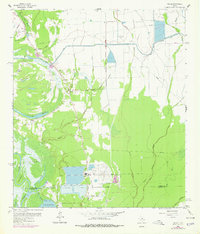
1961 Map of Shiloh
USGS Topo · Published 1978About this map
Moss Bluff and the winding Trinity River define the western landscape of this coastal Texas region in the early 1960s. The settlement of Shiloh serves as a local hub, surrounded by a dense concentration of family and community landmarks, including the St Thomas Ch and the Mount Zion Sch. Genealogists will find an exceptional number of burial sites documented across the terrain, from Miller Cem near Black Gully to the Worthy Cem further south.
Find a feature on this map
52 named features on this map. Tap any name to fly to it.
Don’t see what you’re looking for? This feature index may not catch every label — zoom into the map to look around manually.
Map Details
Editions of this 1961 Shiloh Map
2 editions found

Other maps of this area

1942 · Anahuac
USGS Topo · 1:24,000

1943 · Whites Bayou
USGS Topo · 1:24,000

1943 · Liberty
USGS Topo · 1:125,000

1950 · Houston
USGS Topo · 1:250,000

1954 · Beaumont
USGS Topo · 1:250,000

1955 · Daisetta
USGS Topo · 1:62,500

1955 · Liberty
USGS Topo · 1:62,500

1956 · Houston
USGS Topo · 1:250,000

1957 · Beaumont
USGS Topo · 1:250,000
1961 · Anahuac
USGS Topo · 1:24,000