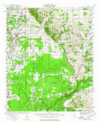
1932 Map of Sledge
USGS Topo · Published 1964About this map
The Tallahatchie River and its intricate network of bayous dominate this delta landscape, where the Illinois Central and Yazoo and Mississippi Valley railroads once anchored the local economy. In the early 1930s, the region was a dense patchwork of small rural communities and social centers, evidenced by numerous landmarks like Mastodon Sch, St Joseph Ch, and the settlement of Sledge. The presence of the Chickasaw Boundary Line crossing the terrain provides a window into older jurisdictional divisions that persisted into the twentieth century.
Find a feature on this map
89 named features on this map. Tap any name to fly to it.
Don’t see what you’re looking for? This feature index may not catch every label — zoom into the map to look around manually.
Map Details
Editions of this 1932 Sledge Map
2 editions found
Other maps of this area

1908 · Walnut Lake
USGS Topo · 1:24,000

1910 · Walnut Lake
USGS Topo · 1:31,680

1932 · Sledge
USGS Topo · 1:48,000

1932 · Tutwiler
USGS Topo · 1:48,000

1932 · Marks
USGS Topo · 1:48,000

1932 · Crenshaw
USGS Topo · 1:62,500

1935 · Crowder
USGS Topo · 1:62,500

1935 · Marks
USGS Topo · 1:62,500

1935 · Crenshaw
USGS Topo · 1:62,500

1935 · Tutwiler
USGS Topo · 1:62,500