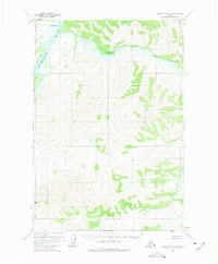
1954 Map of Sleetmute C-6
USGS Topo · Published 1975About this map
The Kuskokwim River serves as the primary artery through this interior Alaskan wilderness, as seen in this 1954 topographic survey. At the northern bend of the river sits Oskawalik, a key point of reference where the Oskawalik River joins the main flow. The terrain is marked by isolated human markers, including a Cabin and Caches, indicating the seasonal or nomadic life typical of the Bethel region mid-century. Mapping in this era was conducted via photogrammetric methods from 1953 aerial photography, capturing the landscape before extensive modern changes.
Find a feature on this map
10 named features on this map. Tap any name to fly to it.
Don’t see what you’re looking for? This feature index may not catch every label — zoom into the map to look around manually.
Map Details
Editions of this 1954 Sleetmute C-6 Map
2 editions found
Other maps of this area

1950 · Sleetmute
USGS Topo · 1:250,000

1954 · Sleetmute D-5
USGS Topo · 1:63,360

1954 · Sleetmute D-6
USGS Topo · 1:63,360
1954 · Sleetmute D-7
USGS Topo · 1:63,360

1954 · Sleetmute C-6
USGS Topo · 1:63,360

1954 · Sleetmute C-5
USGS Topo · 1:63,360

1954 · Sleetmute
USGS Topo · 1:250,000

1954 · Sleetmute B-5
USGS Topo · 1:63,360

1954 · Sleetmute B-6
USGS Topo · 1:63,360

1954 · Sleetmute B-7
USGS Topo · 1:63,360