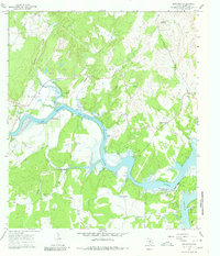
1967 Map of Smithwick
USGS Topo · Published 1980About this map
Lake Travis dominates this Texas Hill Country landscape, marking the winding course of the Colorado River as it carves through the rugged limestone terrain of Burnet County. The settlement of Smithwick sits near the eastern bank, while family-history researchers can find numerous small burial grounds scattered across the upland plateaus, including Richland Cem, Pangle Cem, and Richter Cem. To the south, the Spicewood Beach Landing Strip appears near the water's edge at Eagle Bluffs, reflecting the area's mid-century recreational development. The map also documents the intricate drainage systems feeding the river, such as Hickory Creek, Camp Creek, and Double Horn Creek. Notable landmarks like Wildcat Mountain and the sheltered Pleasant Valley provide clear topographical context for the rural holdings and ranch lands identified by the fine dashed fence lines of the era.
Find a feature on this map
30 named features on this map. Tap any name to fly to it.
Don’t see what you’re looking for? This feature index may not catch every label — zoom into the map to look around manually.
Map Details
Editions of this 1967 Smithwick Map
3 editions found
Other maps of this area

1887 · Blanco
USGS Topo · 1:125,000

1887 · Burnet
USGS Topo · 1:125,000

1893 · Burnet
USGS Topo · 1:125,000

1894 · Blanco
USGS Topo · 1:125,000

1903 · Burnet
USGS Topo · 1:125,000

1909 · Burnet
USGS Topo · 1:125,000

1925 · Burnet 3-d
USGS Topo · 1:48,000

1929 · Marble Falls
USGS Topo · 1:62,500

1930 · Blanco-1
USGS Topo · 1:48,000

1932 · Marble Falls
USGS Topo · 1:62,500