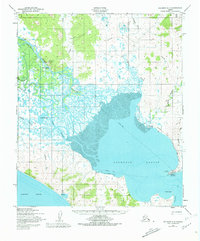
1950 Map of Solomon C-3
USGS Topo · Published 1981About this map
Golovnin Lagoon dominates this coastal landscape on the Seward Peninsula, serving as the central basin where the Fish River and Mudyutok River meet the sea. In the mid-twentieth century, life here revolved around the water and seasonal movement, evidenced by the prominent Winter Trail cutting across the frozen expanse and the various landing strips servicing remote outposts. The settlement of Golovin (Cheenik) stands near the mouth of the lagoon, while White Mountain sits further inland along the riverbanks, marked by its own Corp Bdy.
Find a feature on this map
27 named features on this map. Tap any name to fly to it.
Don’t see what you’re looking for? This feature index may not catch every label — zoom into the map to look around manually.
Map Details
Editions of this 1950 Solomon C-3 Map
3 editions found
Other maps of this area

1950 · Solomon B-3
USGS Topo · 1:63,360

1950 · Solomon B-2
USGS Topo · 1:63,360

1950 · Solomon C-4
USGS Topo · 1:63,360

1950 · Solomon D-2
USGS Topo · 1:63,360

1950 · Solomon C-2
USGS Topo · 1:63,360

1950 · Solomon D-3
USGS Topo · 1:63,360

1950 · Solomon
USGS Topo · 1:250,000

1950 · Solomon C-3
USGS Topo · 1:63,360

1950 · Solomon D-4
USGS Topo · 1:63,360

1951 · Solomon
USGS Topo · 1:250,000