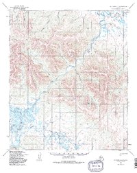
1950 Map of Solomon D-3
USGS Topo · Published 1985About this map
The Fish River dominates this landscape on the Seward Peninsula, winding through a complex network of tributaries and seasonal waterways at mid-century. Several Cabins are situated along its banks, suggesting the localized subsistence or small-scale mining activity common to this region of the Alaska interior. The confluence of the Pargon River and the braided channels of Steamboat Slough reveal a highly dynamic aquatic environment where water levels shifted with the seasons. Overland transit was largely restricted to the Winter Trail, reflecting the isolation of the area before modern road development. This route connects various drainages, including California Creek and Slate Creek, providing essential access to high ground near Mt Wick. A remote Landing Strip further emphasizes the reliance on bush aviation to reach these interior drainages during the short summer months.
Find a feature on this map
23 named features on this map. Tap any name to fly to it.
Don’t see what you’re looking for? This feature index may not catch every label — zoom into the map to look around manually.
Map Details
Editions of this 1950 Solomon D-3 Map
4 editions found
Other maps of this area

1950 · Bendeleben A-4
USGS Topo · 1:63,360

1950 · Bendeleben A-3
USGS Topo · 1:63,360

1950 · Bendeleben A-2
USGS Topo · 1:63,360

1950 · Solomon C-4
USGS Topo · 1:63,360

1950 · Solomon D-2
USGS Topo · 1:63,360

1950 · Solomon C-2
USGS Topo · 1:63,360

1950 · Bendeleben
USGS Topo · 1:250,000

1950 · Solomon D-3
USGS Topo · 1:63,360

1950 · Solomon
USGS Topo · 1:250,000

1950 · Solomon C-3
USGS Topo · 1:63,360