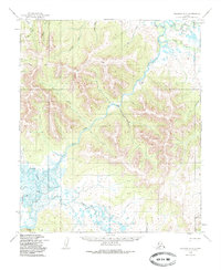
1950 Map of Solomon D-3
USGS Topo · Published 1985About this map
Niukluk River and the Fish River converge in this remote landscape, defining a network of wetlands and meandering waterways that include Steamboat Slough and the Etchepuk River. Rising above the river valleys, Mt Wick serves as a prominent landmark in the western highlands. The map reflects a mid-century period of subsistence and light transport, evidenced by scattered Cabins and a singular Landing Strip situated along a bend in the river. This environment is crossed by the Winter Trail, which connects the mountainous terrain near California Creek and Cotton Creek to the broader drainage basin. The intricate contour lines and swamp symbols illustrate a challenging Alaskan interior where travel followed the freeze-and-thaw cycles of the watersheds.
Find a feature on this map
22 named features on this map. Tap any name to fly to it.
Don’t see what you’re looking for? This feature index may not catch every label — zoom into the map to look around manually.
Map Details
Editions of this 1950 Solomon D-3 Map
4 editions found
Other maps of this area

1950 · Bendeleben A-4
USGS Topo · 1:63,360

1950 · Bendeleben A-3
USGS Topo · 1:63,360

1950 · Bendeleben A-2
USGS Topo · 1:63,360

1950 · Solomon C-4
USGS Topo · 1:63,360

1950 · Solomon D-2
USGS Topo · 1:63,360

1950 · Solomon C-2
USGS Topo · 1:63,360

1950 · Bendeleben
USGS Topo · 1:250,000

1950 · Solomon D-3
USGS Topo · 1:63,360

1950 · Solomon
USGS Topo · 1:250,000

1950 · Solomon C-3
USGS Topo · 1:63,360