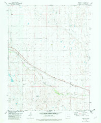
1982 Map of Sorrento
USGS Topo · Published 1982About this map
The Union Pacific railroad corridor defines the development of this Cheyenne County landscape, running parallel to the winding course of Big Sandy Creek. Near the siding at Sorrento, the presence of a Grain Elevator and a series of specialized landmarks like the Branding Corral Windmill and School Section Windmill reflect the area's agricultural and ranching foundations. The reliance on groundwater is evident through the numerous named wells and windmills distributed across the plains, including the Town Windmill and Twin Windmill.
Find a feature on this map
16 named features on this map. Tap any name to fly to it.
Don’t see what you’re looking for? This feature index may not catch every label — zoom into the map to look around manually.
Map Details
Editions of this 1982 Sorrento Map
This is the sole edition of this map. No revisions or reprints were ever made.
Other maps of this area

1891 · Arroyo
USGS Topo · 1:125,000

1891 · Kit Carson
USGS Topo · 1:125,000

1893 · Arroyo
USGS Topo · 1:125,000

1893 · Kit Carson
USGS Topo · 1:125,000

1954 · Lamar
USGS Topo · 1:250,000

1958 · Lamar
USGS Topo · 1:250,000

1978 · Galatea NE
USGS Topo · 1:24,000

1978 · Sanders Ranch
USGS Topo · 1:24,000
1978 · Wild Horse
USGS Topo · 1:24,000

1981 · Cheyenne Wells
USGS Topo · 1:100,000