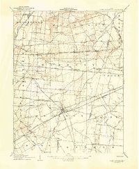
1907 Map of South Charleston
USGS Topo · Published 1943About this map
The town of South Charleston serves as a major hub for a sophisticated network of electric and steam railways at the turn of the century. This landscape is defined by the convergence of the Detroit Toledo and Ironton RR, the Pittsburgh Cincinnati Chicago and St Louis RR, and several electric lines including the Springfield and South Charleston Electric. These transit arteries supported rural settlements like Dolly Varden, Plattsburg, and Lisbon, where farm life remained deeply connected to local institutions. Family-named landmarks such as Yeazel School, Maxie School, and Asbury Church dot the countryside, illustrating the decentralized community structure of early 1900s Clark County. The topography is shaped by the Little Miami River and the headwaters of Paint Creek, creating a well-watered agricultural district where the National Pike and Columbus Road provided essential overland routes for local commerce.
Find a feature on this map
70 named features on this map. Tap any name to fly to it.
Don’t see what you’re looking for? This feature index may not catch every label — zoom into the map to look around manually.
Map Details
Editions of this 1907 South Charleston Map
2 editions found
Other maps of this area

1904 · Springfield
USGS Topo · 1:62,500

1906 · Springfield
USGS Topo · 1:62,500

1906 · Mt Sterling
USGS Topo · 1:62,500

1907 · London
USGS Topo · 1:62,500

1907 · South Charleston
USGS Topo · 1:62,500

1914 · St. Paris
USGS Topo · 1:62,500

1914 · Mechanicsburg
USGS Topo · 1:62,500

1916 · Mechanicsburg
USGS Topo · 1:62,500

1916 · St. Paris
USGS Topo · 1:62,500

1916 · Octa
USGS Topo · 1:62,500